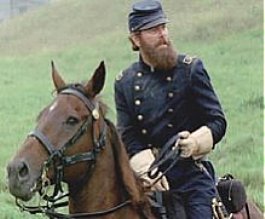
There is a passage in the book 'Stonewall In the Valley: Thomas J. "Stonewall" Jackson's Shenandoah Valley Campaign , Spring 1862' by Robert G. Tanner that opens . . .
" Between the river-laced Piedmont Region and the matted Allegheny Mountains of the Middle Atlantic states there is a corridor. That corridor, in Virginia, is the Shenandoah Valley. The Valley runs south-westward from the Potomac River more than 150 miles to the James. It is flanked on the east by the Blue Ridge and on the west by the Alleghenies, but the passage between these boundaries is a generally smooth path of clover and blue grass. Indian tribes that followed migrating herds up and down this corridor did not realize that it was one of the great early highways of the New World; they were content to regard it simply as a gift of the stars."
And so it began, leaving home early Monday morning well before sunrise as I usually do when I need to cover a lot of distance the first day.
 Alas, I won't be joined by my good friend and travel companion John due to work. He and I have travelled many miles over the years, and his easy going nature has usually allowed me the grateful pleasure of planning our road trips based on my interests and the places I want to visit. 'As long as I'm riding' is his motto. And if I find myself tramping through a field or burrow for hours on end in search of some Civil War minutia, that's okay with him, too. "Just leave me at the bar," he chuckles.
 I will miss seeing his ST1300 in my mirror
 .
.


An hour and a half later down the QEW I arrive at the Fort Erie border crossing as the morning sky begins to brighten. A quick look see in the Duty Free and another cuppa Timmies as the Peace Bridge across the Niagara River into Buffalo, NY looms. .


 Once across the American border, much of my route will take me south on US219 before linking up with US220, then veering south-east for my destination of Winchester, Virginia.
Shortly south of Buffalo, I hop onto US219 as the early morning mist begins to rise. Always a favourite route of mine into the U.S, it winds its way along sweeping turns, across rolling hills,
 past farmlands and small towns, with the odd stretch of superslab thrown in. Is is a great gateway into the States.
A regular stop of mine whenever I'm on 219, an hour south of Buffalo is the Timmies in Springville. It is one of their relatively few shops sparsely scattered throughout the extreme north-east region of the U.S. This pic is from an earlier visit. Note my previous Kawasaki Nomad and John's ST.

As I look down the highway from the parking lot, sipping my last good cup of coffee for a few days, I wonder if Jimmie Johnson is home . . .


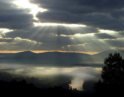
I encounter a stretch of fog at the PA line.
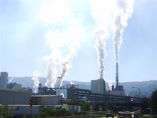 The translucent appearance by the sun of the rising smoke from the Domtar paper mill in Johnsonburg, PA caught my eye. Like many others, this small town of under 3,000 people depends on the mill for its economic survival.
Midmorning and it's time to stop for breakfast at

the 'Hwy. 219 Family Restaurant & Country Store' in Mahaffey.
 After a gut-busting hungryman breakfast, I head southeast to enjoy some winding two-lane country blacktop.

Across the Mason-Dixon line into Maryland, then West Virginia.
 The C&O Canal operated between 1836 and 1924, paralleling the Potomac River from Cumberland, MD to Washington, DC and was a lifeline for business and communities, as coal, lumber, grain, and other agricultural commodities were floated to market. This pic was taken at the Paw Paw site.
A bridge spans the canal.


Into Virginia and coming upon Winchester.

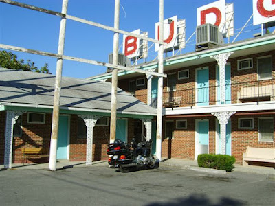 I arrive at the Echo Village Budget Motor Inn for the next few days. Five stars it definitely ain't, but you can't beat twenty six bucks a night.
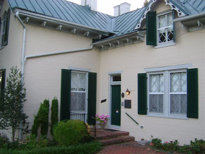
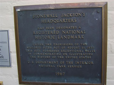
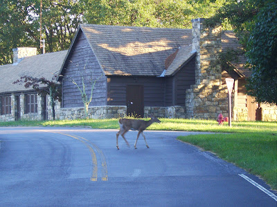
That evening I headed into downtown Winchester to visit 'Stonewall Jackson's Headquarters', a national historic landmark, where Jackson first stayed on his arrival in the Valley in March 1861.


 Then it's back the hotel for some much-need sleep.
Much of the research I used to plan my rides in the Valley came from Dale Coyner's excellent book, 'Motorcycle Journeys Through the Appalachians.' With maps and descriptions, it allowed me to combine some great riding with my Civil war battlefield visits.
Another invaluable source is Delorme Publishing's 'Virginia Atlas & Gazetteer'. You can't do better than Delorme for great topographical mapping.


 From Coyner's book, I will combine 'Stonewall's Valley' and 'Skyline Loop' into a single daytrip for this day, Tuesday.
But first, a stop in the very pretty town of Front Royal where Jackson battled Union forces to re-capture the town


Then I head westward for my first
venture into the Valley.
 The Shenandoah Valley extends 200 miles southward from the northern tip of Virginia to the James River near Roanoke, and stretches some thirty miles across, flanked by the Blue Ridge Mountains in the east and the Allegheny Mountains (part of the Appalachian Mountain range) in the west
Located in the north is the Massanutten Mountains, splitting the Valley east and west for fifty miles, the eastern half called the Page, or Luray Valley.

The Massanutten is made up of parallel ridges containing its own valley, called Fort Valley. It is here where I would foray into.


Southbound on Fort Valley Rd. through George Washington National Forest.

From an outlook high in the Massanutten, Coyner's book eloquences,
"When you top out on the ridge, make a stop and climb off the bike. On the side of the road facing the east is a beautiful view of the eastern portion of the Valley with the Blue Ridge in the distance and the town of Luray directly below. The south fork of the Shenandoah River glistens in the foreground. The view alone is reason enough to make this ride-it's something you can take with you that few other will ever see."
Along the top of the distant Blue Ridge Mountains runs Skyline Drive and Shenandoah National Forest.
Leaving the Massanutten I head east for eight miles for a special visit to the Country Kitchen Restaurant in New Market. Coyner's book raves about this place -
"Do not go to New Market and eat anywhere else. This is the real deal. I don't know anywhere else where you can find peanut soup listed on the menu as  a regular item, and their "Virginia Fried Chicken" puts the Colonel to shame. The decor is strictly fifties, which is part of the charm, but rather seeming time-worn it looks as clean and fresh as if it opened for business yesterday. I've had lots of good meals on my journeys through the mountains, but this one is the best."
 a regular item, and their "Virginia Fried Chicken" puts the Colonel to shame. The decor is strictly fifties, which is part of the charm, but rather seeming time-worn it looks as clean and fresh as if it opened for business yesterday. I've had lots of good meals on my journeys through the mountains, but this one is the best."
He's right, too. The peanut soup is like nothing I've ever had, and the chicken is amazing. They say the pork chops are pretty special, too. Next time!


 From New Market, I backtracked westward on US211, I came across White House Bridge. This local landmark was where Jackson's cavalry chief Turner Ashby burned the nearby bridge to slow Union pursuit of his forces.
Continuing westward, crossing the Massanutten, through Page Valley, where I crest the Blue Ridge Mountains at Thornton Gap. I continue down the other side, a five-mile descent with hairpin turns sharp enough to really scrape the floorboards.
I turn southward skirting the east side of the Blue Ridge past rolling hills and farmland, until I turn back west for my first ride on Skyline Dr.,


From 'The Greatest Single Feature . . A Skyline Drive: 75 Years of Mountaintop Motoring', by Reed L. Engle -
"In 1923, the Southern Appalachian National Park Committee was created to explore the idea of an eastern national park. Two years later Shenandoah National Park was authorized along with the SANPC's recommendation that a "sky-line highway' be built along the crest of the Blue Ridge Mountains."
Christened Skyline Drive, running the length of the 200,000 acres comprising Shenandoah National Park, it is 105 miles of riding bliss, beginning below the town of Front Royal, bisected at Thornton Gap by US211 and Swift Run Gap by US33, ending at Rockfish Gap by I-64, where the Blue Ridge Parkway begins. Chockful of sweeping turns, mountainous climbs and brake-testing descents, through canopies of forests, and numerous stops and outlooks with views that span the countryside in all directions. It is a roadway to take your time on and savour the magnificence of the mountain landscape.
 Heading north on Skyline Drive from Swift Run Gap, I come to my first grand vista at South River Overlook. Looking westward across the Page Valley is the south end of Massanutten Mountain. The highway in the distance is US33 that skirts the bottom of the mountain.


 The notch in the distant Massanutten Mountains is New Market Gap where US211 bisects.
 Located south of Thornton Gap is Marys Rock Tunnel, the only tunnel on Skyline Drive, finished in January 1932 and bored through 700 feet of the oldest visible rock along the Drive, dating to a billion years.It is thought that is was named after the daughter of Francis Thornton, who built Montpelier Mansion nearby in the Piedmont, and of whom Thornton Gap is named after.
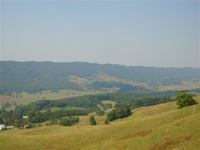
 At 2,800 feet, Range View outlook is one the best on a clear day. You can look toward the Piedmont, and southwest down the length of the Blue Ridge Mts. at some of the highest peaks in the park.
In the distance is the north end of the Massanutten Mountains.
 My last stop was Dickey Ridge Visitor Center before it was time, 270 miles later, to head back to the hotel.
My last stop was Dickey Ridge Visitor Center before it was time, 270 miles later, to head back to the hotel.Referring once more to Dale Coyner's 'Motorcyle Journeys Through the Appalachians', my route this third day, Wednesday, will be the 'Highland Loop', taking me further south and west outside the Valley.
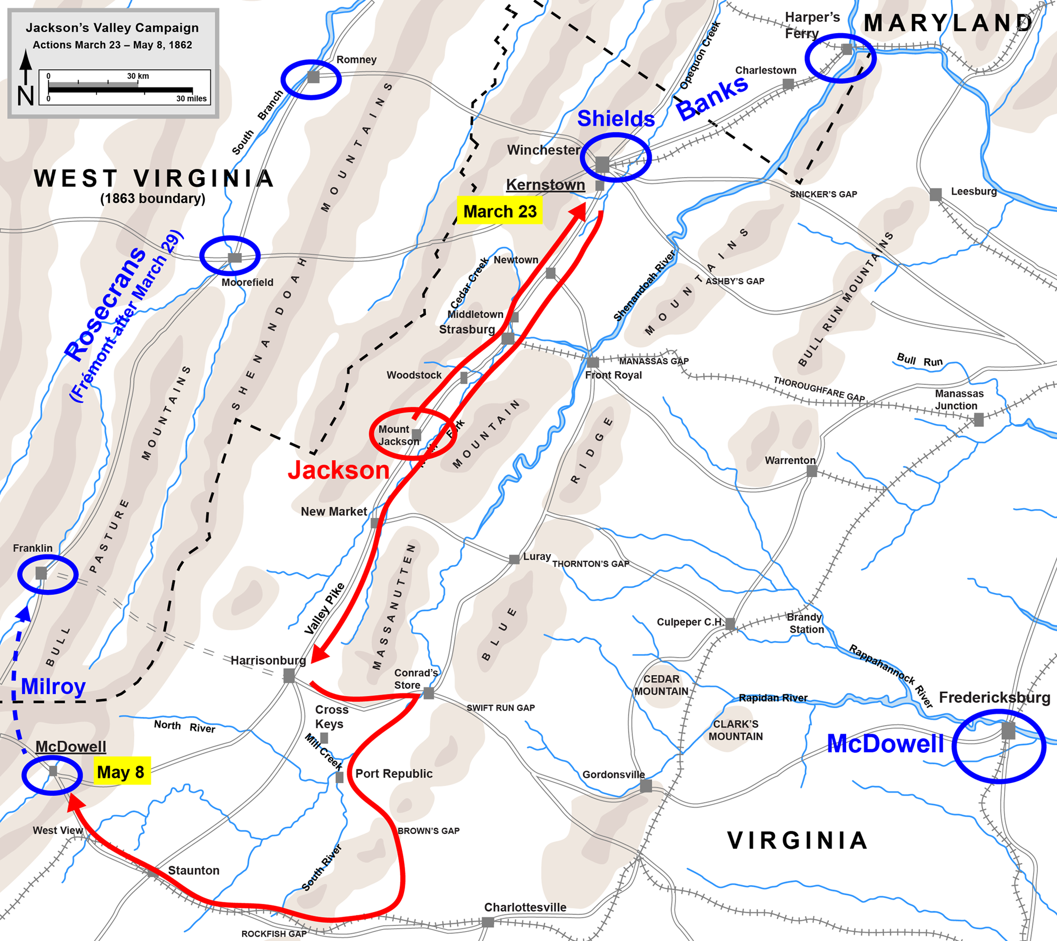
But first I headed a few miles up the road to the Kernstown Battlefield.


 This was Gen. Jackson's first clash with Union forces trying to hook up with Gen. McClellan's army for the drive to Richmond. It was Jackson's only tactical defeat in the Valley. But the battle was a strategic victory by unhinging the Union offensive in Virginia, causing Union Gen. Banks to remain in the Valley
From Kernstown I headed southward. Instead of I-81, I took the paralleling US 11, otherwise called the Valley Pike, or Old Valley Pike. First as a path used by native Indians, it became a major transportation route up and down the Valley for settlers, then by Jackson to move his troops rapidly to meet the unsuspecting Union armies.
A total of nine battles were fought in the vicinity of the Valley Pike, expediting armies of both sides throughout the course of the War.
 A long 95 miles later, passing through the towns of Middleburg, Strasburg, New Market, and Harrisonburg, I approach Staunton for this westward view toward the Appalachians, my destination and beyond.
 Running wide open west on US250, east of Stauntion


 East of the village of Head Waters, high atop Shenadoah Mountain, I come across Fort Edward Johnson, named for Confed. Gen. Edward Johnson whose troops camped and constructed fortifications here before the Battle of McDowell, west of here, when Johnson would block the thrust eastward into the Valley by Union Brig. Gens. Robert Milroy and John Fremont.
Looking westward across the from the fort, the view is spectacular.
Wrote Frank B. Jones, Major, 2nd VA Infantry in a Tuesday, 13 May 1862 entry in his diary -
" I have been much struck, with the wild mountain scenery. The Shenandoah Mt. Pass is grand indeed, you ascend to the very top of the mountain and from there you see as far as the eyes can reach. Mtn. after Mtn. in every variety of shape and grandeur whilst away down below a little valley and stream with winding road, winding around from Mt. to Mt. to descent the grade. After reaching this valley we ascent the full view of the James to a point where he water turn the other way and then we discerned the headwaters of the Potamac. The Mtn. tower above us beautifully.
Every now and then you will find a fresh and sparkling stream gushing ot of the mtn. side and running awy in to the larger streams of the Valley."

I continue motoring westward, approaching McDowell.
 Only a sole marker by the road?

I continue motoring westward, approaching McDowell.
Only a sole marker by the road? The town of Monterey nestled picturesque in the valley.

 One of the many ranges and valleys that US250 traverses across the Appalachians, making for some awesome riding !
 One of many stops during the day to take in the grandeur and majesty of the Virginia landscape. With a mellow Backwoods in one hand, a gentle sip from the hip flask in the other, life doesn't get much better . . . .
 I continued westward 250, across the West Virginia line before turning south on highways 28 and 92, then returning east on 39 back into Virginia. More fabulous riding before pausing at Goshen Pass.
 Northbound on 252 through a canopy of trees, this narrow highway demands lower speeds to take in the winding road, across rolling hills surrounded by many acreages of farmland and horse breeders encased in stunning picket-fenced country side.
Soon I hop onto I-81 for the long haul back to the hotel on which, incidentally, I would incur, in my haste to return before too long into the night, my first speeding ticket on the Goldwing, courtesy of the Virginia State Police. Oh, well . . .
Twelve hours and 375 miles later, I'm gonna sleep well tonight.
My pre-planning for this trip had me doing the Valley Run from Coyner's book for today, Thursday, but after three days of hard riding I decided to take it easier and allow myself to ride the entire Skyline Drive. In hindsight, I should have located a base hotel further south, a location more central to the rides I wanted to make. Mental note for next time . . .


After three days, it's long past due I stop in at the Cracker Barrel Old Country Store and Restaurant for breakfast. I seek these out every time I'm in the States. Breakfast, lunch, or dinner they're great. Sure wish they had them in Canada as, coincidentally, my good friend Jax in Tennessee longs for Tim Hortons where he resides.


 Afterwards, it's a short hop into downtown Winchester where I park the bike a go for stroll through the historic section.


 Climbing back on the Wing, a short jaunt to the Winchester Visitor Center which sits on the property first settled by Abraham Hollingsworth in 1734. The oldest buildings in the town which, fortunately, survived the battles that took place nearby.


Then it's back on Skyline Drive, entering at the North Entrance. Beautiful skies, warm temps, I knew I was gonna enjoy this last day in the Shenandoah.

A stop at Dickey Ridge Visitor Center which was closed when I went by on Tuesday.
 Another stop at Hogback Lookout. This is probably my favourite lookout for the sweeping view of Valley it affords situated on the bend in the road. And the large expanse of sky causes me to wonder how beautiful the stars must be at night. From Coyner's 'Motorcycle Journeys . . '
"The big secret that few people know about it riding Skyline at night. You can witness some spectacular sunsets here, but when the sky darkens, the heavens upon before you eyes and you'll understand why the Shenandoah means "daughter of the stars . . . Once you get out of the lights of the Front Royal area you can pick an overlook, park the bike, and enjoy it."
Certainly something this astronomy enthusiast to plan for next time.


Further down the road, a stop at Big Meadows Visitor Center for a coffee.

 Once more on the bike southward, I come across another view of the south end of Massanutten Mountain from Two Mile Run overlook.
 After completing Skyline Drive, I exited the south end at Rockfish Gap and turned northward on US340. Having forgoed the Valley Run routing, I resigned myself to the fact I would not complete my Stonewall Jackson battle-site visits in the Valley by passing on the villages of Port Republic and Cross Keys which were on the itinerary.
Imagine my wonderful surprise when I came upon this sign north of the village of Grottoes.
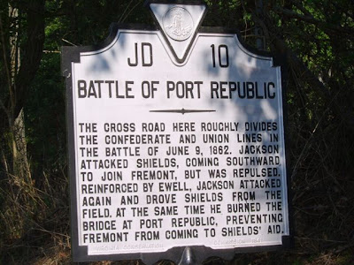
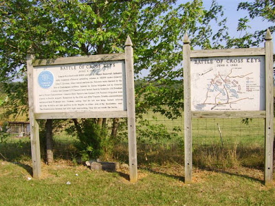
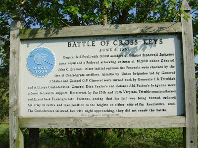
In early June 1862, two separate Union forces under Gens. Banks and Fremont pursued Jackson southward but failed to link up for a combined assault due to rain-swollen terrain and rivers. Fremont was strung out several miles to the west at Cross Keys while Banks neared Port Republic. The Confederates, under Gen. Richard Ewell, defeated Fremont on June 8 while Jackson drove Banks from the field the next day.


 The key to the Battle of Port Republic, which took place on June 9, 1862 was this hill called the 'Coaling' on which Union artillery commanded the field. Three desperate attempts by the Stonewall Brigade finally dislodged federal forces who withdrew. These pics were taken at US340 and Port Republic Rd.
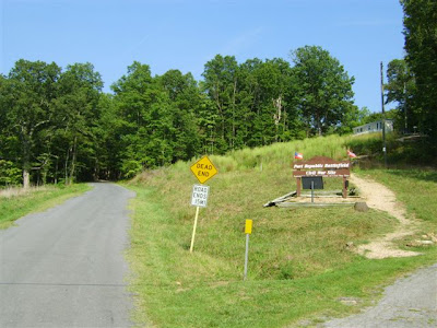
After a quick check on the GPS, I make the shorthop to Cross Keys.


 Overlooking the battlefield eastward from Hwy. 276 & Battlefield. The Blue Ridge Mountains are in the distance.
 After these two battles, the remaining Union armies were ordered to halt their pursuit of Jackson and leave the Valley for Fredericksburg, Virginia, thus securing the Valley for the Confederacy. Gen. Jackson had done his job by drawing 60,000 Federal soldiers away from McClennan's Peninsula Campaign. Soon Jackson would prepare to join Robert E. Lee's Army of Northern Virginia in the defense of Richmond, leaving the Valley for the last time.
 This view of the local cemetery across the street looks northward directly at the south end of Massanutten Mountain.
Very pleased with myself that I was able to complete what I set out to do on this trip, I jumped back on the highway for the northbound trip to the hotel. US340 will take me through the Page Valley between the east side of the Massanutten and Blue Ridge Mountains, where earlier I-81/US11 had me travelling earlier along the west side of the Massanutten.
No matter where I ventured the last four days, I found myself longing for these roads back home. All we have in southern Ontario is straight, flat, and boring . . .

My last evening and time to savour my Shenandoah experience with a hearty steak at the Outback Steakhouse.
 Leaving on Friday for home, I had planned to spend an extra day in Gettysburg. But the remnants of Hurricane Hanna was chugging up the coast and forecast to inundate the region with rain on Saturday, so it was best that I make a beeline for home.
Leaving once again before sunrise, I head north-west from Winchester on the very scenic US50, where I stop for breakfast at the Perkins in Cumberland, Maryland.

Sheesh, you just can't get away from road construction, can you . . .
 After crossing the border into Canada by mid afternoon, I knew I was home when I pulled in here, off the QEW near St. Catherines.
 * * * *
Five days and 1900 miles in total, I plan to do this again someday !!


